Winu — Can a Physics-First, Public-Data Workflow See a Covered Cu–Au Deposit It Was Never Shown?
Tolun AI · 2026-06-18 · blind public-data case study (Paterson Province, Western Australia)
This is a Winu case study built on 100% public data — Geoscience Australia's 2019 national geophysical grids and surface-geology service, plus the published deposit location. No Rio Tinto data was used (the Winu drilling and assays are confidential). The test is deliberately honest: we located the deposit from its published coordinates, then asked the independent national datasets a blind question — does the covered Winu–Ngapakarra system express in regional public geophysics, and which method carries the signal? The answer is specific and checkable, and it sets up exactly where Tolun's engine — and mass-balance geochemistry of the kind Halley (2015) describes — adds value.
1 · The deposit and why it is a hard test
Winu–Ngapakarra is an intrusion-related Cu–Au system in the Great Sandy Desert, Paterson Province, discovered by Rio Tinto in 2017. Published descriptions classify it as transitional between a reduced and oxidised porphyry system, genetically related to a deep granitoid pluton, mineralised in the Neoproterozoic (~658–655 Ma). Critically, it lies under at least 50–100 m of younger (Permian) sedimentary cover — deeply weathered sandstones, diamictites and mudstones.
That cover is the whole point. Cover defeats the near-surface methods: the deposit's alteration footprint never reaches the surface, so anything that reads the top of the ground — radiometrics (gamma-ray senses only the top ~30 cm), conventional rock-chip / soil lithogeochemistry, and mapping — sees the cover, not the system. The methods that can see through cover are the deep-looking geophysics — potential fields (gravity, magnetics); electrical / electromagnetic methods (IP, resistivity, airborne EM, magnetotellurics), where IP senses disseminated sulfide directly and is often the most diagnostic under cover; and active and passive seismic — with passive seismic (ambient-noise tomography, HVSR / microtremor) a fast, cheap, low-impact way to image the cover itself (sediment thickness, depth-to-basement, shear-velocity structure), while active reflection/refraction adds higher resolution at higher cost — together with cover-piercing geochemistry (partial-leach / mobile-metal-ion at surface, and downhole geochemistry where holes exist).
This study deliberately uses only the free national potential-field and radiometric grids (gravity, magnetics, radiometrics) because those are what any explorer can pull at zero cost — IP, EM and seismic would also penetrate cover but are survey-specific, not free national layers, so they sit outside a public-data test. The lesson is the same as our NSW Cadia/Northparkes study: each deposit has a fingerprint, and the cover decides which methods can read it.
| Property | Winu | Ngapakarra |
|---|---|---|
| Latitude (published) | −20.7239° | −20.7319° |
| Longitude (published) | 121.7411° | 121.7681° |
| Cover | ≥ 50–100 m Permian | as Winu |
| Style | Intrusion-related Cu–Au, transitional porphyry | as Winu |
(Coordinates from the PorterGeo deposit database; cross-checked against Rio Tinto's "~330 km SE of Port Hedland" — the published point sits ~328 km E of Port Hedland, consistent. We explicitly rejected a web-summarised coordinate of 119.23°E as wrong — it falls in the Pilbara, not the Paterson Province.)
2 · Method — public data only, no training on the answer
- Located the window from the published deposit coordinate (above) — a 0.80° × 0.75° box (lon 121.35–122.15, lat −21.10 to −20.35) centred on Winu.
- Pulled regional geophysics from Geoscience Australia's 2019 national grids via the live WCS service, windowed to the box (no multi-GB downloads): Bouguer gravity (CBA), magnetics (VRTP 1st-vertical-derivative and analytic signal), and radiometrics (K, Th, U).
- Pulled surface geology from GA's Surface Geology REST export over the same box.
- Extracted the geophysical signature at the deposit — the value of each layer at Winu's published coordinate, expressed as a percentile of the whole window. This is the blind question: we never used the deposit to choose the window or tune anything — we simply asked where Winu falls in each independent national dataset.
- Pulled the public geochemistry over the same window — GSWA's open-file WACHEM multi-element drill-core compilation (84 elements per sample) — to test whether free geochemistry can act as a fertility discriminator (Section 6).
3 · Regional geophysics (with the deposit pinned)
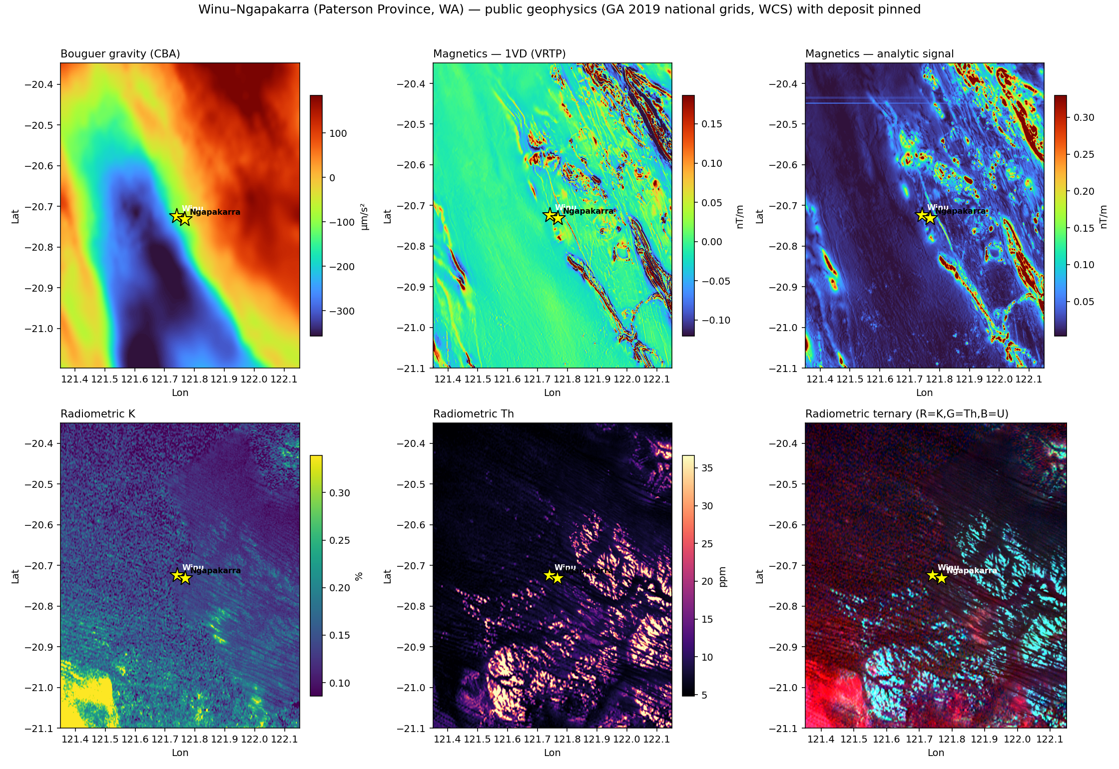 Six public layers over the Winu window, deposit pinned (yellow stars). Bouguer gravity; magnetic 1VD and analytic signal (both reduced-to-pole vertically); radiometric K, Th, and the K–Th–U ternary. Winu sits on the magnetic fabric, on the flank of a NW–SE gravity gradient, and in a radiometrically quiet (cover-masked) zone.
4 · The signature at Winu — what each method says
| Layer | Value at Winu | Field percentile | Reads as |
|---|---|---|---|
| Magnetics — 1VD | 0.314 nT/m | 99.1 % | strong, near-top-of-field magnetic anomaly |
| Magnetics — analytic signal | 0.324 | 97.9 % | corroborates: a real magnetic source, not an edge artefact |
| Bouguer gravity (CBA) | −110 µm/s² | 35.7 % | neutral / mild low — on a gradient, not a discrete high |
| Radiometric K | 0.118 % | 24.3 % | low — cover-masked, as expected |
| Radiometric Th | 7.0 ppm | 50.1 % | background |
| Radiometric U | 0.69 ppm | 37.3 % | background |
The magnetic method alone flags Winu in the top ~1–2 % of the region, in two independent magnetic measures. Gravity is neutral; radiometrics are quiet. That is not a failure of gravity or radiometrics — it is the fingerprint: a magnetite-bearing granitoid pluton drives the magnetic signal, while 50–100 m of Permian cover masks any radiometric or surface-geochemical expression, and the system is not a strong density contrast at this regional resolution.
But detection is not depth — and this is the key caveat. A potential-field anomaly tells us something is there and where in plan; it does not reliably tell us how deep. Potential fields are inherently non-unique in depth (the same surface anomaly can come from a shallow weak source or a deep strong one — Green's equivalent source), and cover makes this worse: the extra source-to-sensor distance acts as a low-pass filter that strips the short-wavelength content carrying depth and geometry, so the anomaly arrives broad and smooth and the depth information is largely gone. This is exactly why potential-field inversion needs explicit depth weighting (Li & Oldenburg 1998) and why depth must be reported as an uncertainty range, not a number. The 99th-percentile result above is therefore a detection in plan, not a 3-D model — which is precisely what makes the joint-inversion-with-uncertainty in Section 8 the load-bearing piece, not a flourish.
5 · Comparison to the known deposit model
The published model is an intrusion-related Cu–Au system tied to a deep granitoid pluton, under cover. The blind public-data signature matches it cleanly:
- Magnetic high (1VD + analytic signal): consistent with the magnetite-bearing pluton the deposit is genetically tied to. The signal that should survive cover is the one that does.
- Cover-masked radiometrics: K, Th, U all background-to-low at the deposit — the near-surface method correctly sees only the Permian cover, exactly as theory predicts.
- Gravity on a gradient, not a peak: consistent with a structurally controlled, intrusion-related system rather than a massive dense body.
This is a real, model-consistent result obtained without any Rio Tinto data.
6 · The geochem discriminator layer — what free data can and cannot do
The blind geophysics flags Winu, but cannot by itself separate a fertile pluton from the region's many barren magnetic highs. That discriminator is geochemistry → alteration / mineralogy — the mass-balance approach set out in Halley (2015), "Geochemistry, the new geophysics?". So we pulled the public geochemistry over the same window and analysed it.
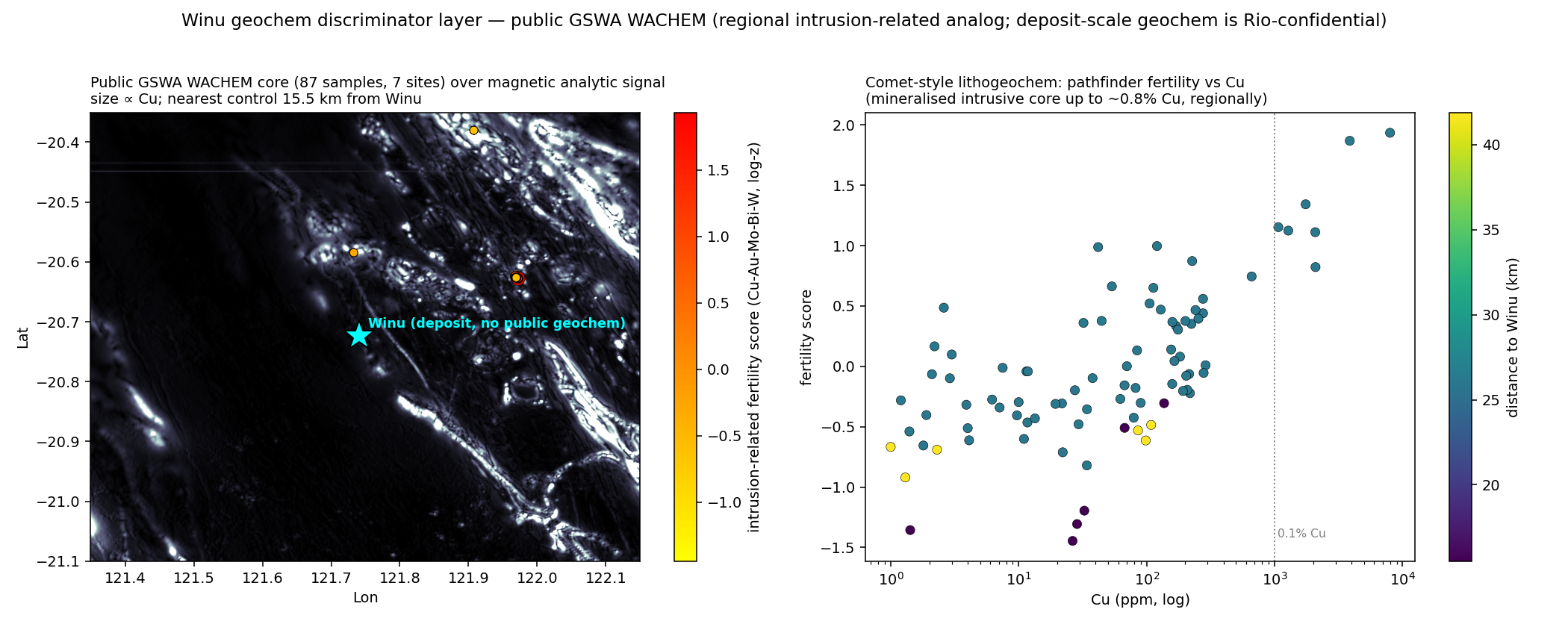 Left: the 87 public GSWA WACHEM drill-core samples (7 sites) over the magnetic analytic signal, coloured by an intrusion-related fertility score (log-standardised Cu–Au–Mo–Bi–W) and sized by Cu — the nearest control is 15.5 km from Winu. Right: pathfinder fertility vs Cu (log), coloured by distance to Winu; mineralised intrusive core reaches ~0.8 % Cu regionally.
What public geochem gives us (regional): 87 drill-core samples in the window, 84 elements each (full ICP/XRF — Cu, Au, Mo, Bi, W, Sb, As, Pb, Zn, Ag, the REE, major oxides, S). The most fertile public samples (~26 km away) carry Cu up to 0.8 %, Au 0.36 ppm, Bi 90–118 ppm, W up to 10 ppm — the classic Cu–Au–Bi–W intrusion-related pathfinder association, in the same intrusive host (granodiorite–diorite–syenogranite) as Winu. The free data independently confirms a fertile intrusion-related setting across this part of the Paterson — exactly the lithogeochemical signal that class of method is built to read.
What it cannot do (deposit-scale): there are zero public samples on Winu or Ngapakarra — the nearest is 15.5 km away, and Rio Tinto's over-deposit drilling geochemistry is confidential (held under tenement, not in WACHEM). The headline GSWA geochem product is interactive-download-only (DASC); the scriptable equivalent is the SLIP/WACHEM feature service used here. National GA NGSA is ~1 site / 5,500 km² — effectively nil inside this window. So public geochemistry supports a clean-room regional fertility analog, not direct over-deposit validation.
We did not just describe the discriminator — we ran it. The public WACHEM majors carry the minimum input set the method needs (Al, Ca, Fe, K, Mg, Na, S from a 4-acid digest). Using Tolun's Stage-1 mass-balance method (assay → mineralogy → physical properties — the same class of mass-balance method), we inverted the 87 public samples into modelled modal mineralogy and the standard alteration indices:
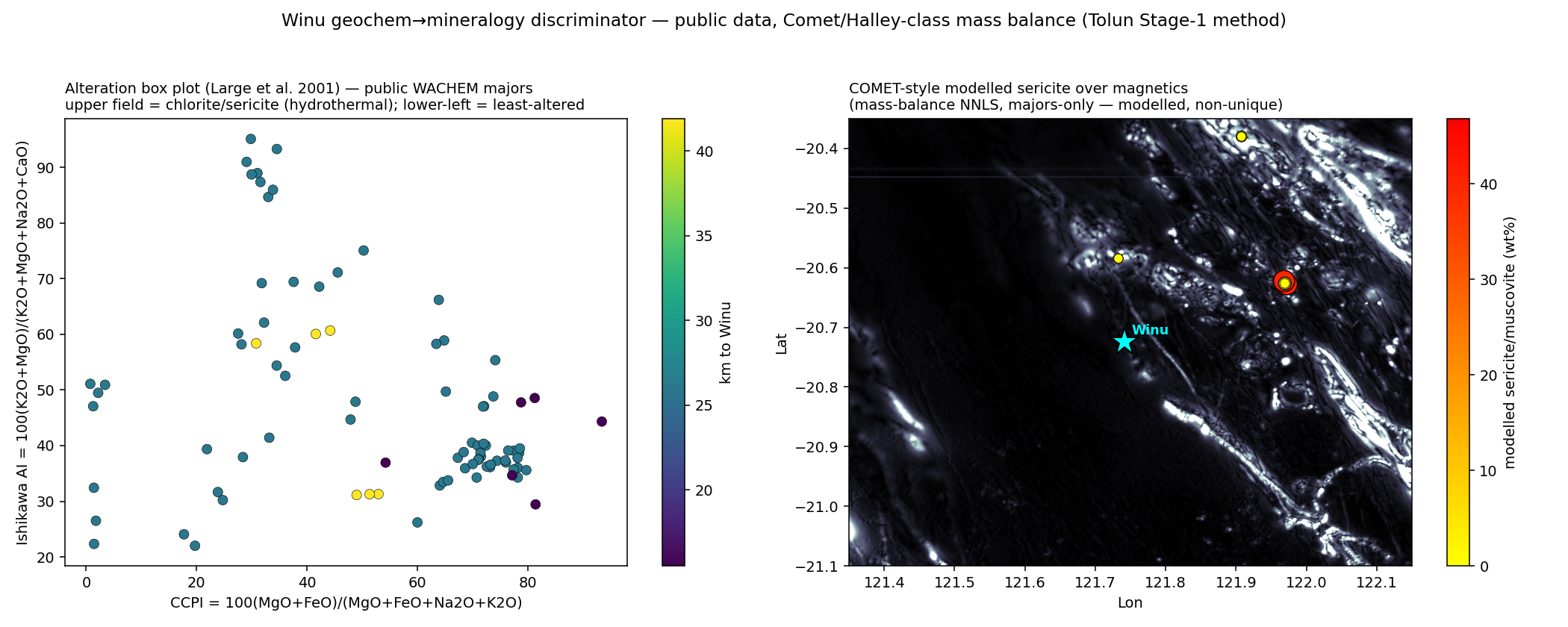 Left: the Large et al. (2001) alteration box plot (Ishikawa AI vs CCPI) from the public majors — samples spread from least-altered country rock toward the chlorite–sericite hydrothermal field. Right: modelled sericite/muscovite (mass-balance NNLS, 11-mineral porphyry library) over the magnetic analytic signal, Winu pinned.
The inversion recovers a geologically sensible assemblage (quartz ~37%, plagioclase + K-feldspar, chlorite, with modelled sericite reaching ~47% in the most altered samples), and the box plot spreads toward the chlorite–sericite field — the hydrothermal alteration vector. And the honest limits are exactly the ones the published method names: this is modelled, not measured mineralogy; majors-only makes the mica/sulphide split non-unique (muscovite vs illite vs sericite all share Al–K); Fe is populated on only 8 of 87 samples, so chlorite/pyrite are weakly constrained; and the samples sit 15–42 km from Winu. It is a regional alteration-vectoring demonstration on free data — calibration against XRD/QEMSCAN and the deposit-scale assays would tighten it. (This is the same engine primitive as the reconciliation/geometallurgy chain, not a one-off script.)
This is the crux of the value argument. The layer that turns "Winu is one of many magnetic highs" into "Winu is the fertile one" exists — but at deposit scale it is precisely the data that is not free. That is why the discriminator has to be built, governed and run as a system, and why an explorer's own (or a partner's) geochemistry is where Tolun's geochem→mineralogy engine earns its keep.
7 · The honest limits — what this does not claim
- This is a coincidence test at one known point, not a from-scratch ranking. We asked "does Winu light up?", not "can we rank every anomaly in the Paterson and find Winu at #1?". Regional magnetics here is busy — there are many magnetic highs (see the panel). A magnetic anomaly is necessary but nowhere near sufficient; thousands of barren magnetic features exist.
- Potential fields detect, but do not resolve depth under cover. The magnetic percentile locates Winu in plan; it says little about how deep the pluton sits. Depth from potential fields is non-unique to begin with, and cover strips the short-wavelength content that would pin it — so depth and geometry are uncertainty-dominated (the reason depth weighting exists). Treat the 2-D anomaly as a detection, never as a depth model. Other cover-penetrating methods (IP/EM, seismic) carry depth/property information potential fields lack, but are not free national layers.
- No drilling, no assays. Rio's holes are confidential, so we cannot validate against grade or geometry — only against the published model and the regional signature.
- Single-point sampling caveat: the 99th-percentile magnetic value is corroborated by the analytic signal (97.9 %), which guards against a single hot pixel, but a full anomaly-by-anomaly treatment is the proper next step.
- The deposit-scale discriminator is the one piece that isn't free (Section 6). Public WACHEM geochem confirms a fertile intrusion-related setting regionally (Cu–Au–Bi–W pathfinders in mineralised core 15–42 km away) but has no sample on Winu itself; the over-deposit geochemistry that would clinch fertility is Rio-confidential. The covered system's chemistry is recoverable from cover-piercing / drill geochemistry, not from this regional public layer.
7b · Addendum (2026-07-11) — the cross-validated ranking number
The companion parent study (2026-06-18, committed study record) did run the from-scratch ranking this section notes the coincidence test is not: a window-wide prospectivity model over the same public layers, scored by spatial-block cross-validation. The result is published exactly as measured: AUC 0.57 ± 0.02 — modest, and reported as the honest number it is — with Winu itself landing in the top 13 % of window area. Read together with Section 4: the public layers detect (a top-1 % anomaly at the known point) but rank weakly (AUC 0.57) — which is precisely the gap the deposit-scale discriminator (Section 6) and the engine (Section 8) exist to close. Both figures are quoted from the committed study record, tolerances included.
8 · Where Tolun turns "Winu is magnetic" into a ranked target
This study deliberately stops at the public regional layer. The Tolun engine is built to carry it the rest of the way:
- Joint inversion with quantified uncertainty — because potential fields alone cannot resolve depth under cover (Section 4), the honest output is a depth posterior, not a depth number: invert magnetics + gravity for a 3-D susceptibility/density body with DRAM-MCMC uncertainty and Li & Oldenburg depth weighting, and join them with the methods that carry independent depth/property constraints — passive seismic (ambient-noise tomography, HVSR) to pin the cover thickness and depth-to-basement that potential fields cannot, plus IP/EM and drilling — so the depth ambiguity is reduced by data, not by assumption. (Tolun's engine already runs ambient-noise tomography, so this is an existing capability, not a wish.) Where in plan we can already see; how deep, and how confident is the part that needs the engine.
- The geochemistry/mineralogy layer — we have already pulled the public WACHEM whole-rock geochemistry (Section 6) and shown the Cu–Au–Bi–W intrusion-related pathfinders regionally. The engine's job is to convert multi-element geochemistry → quantitative alteration/mineralogy → the fertile-vs-barren vector, and to run it on the deposit-scale geochemistry a partner brings — the data that the public layer (Section 6) shows is the missing piece.
- Agentic prospectivity — fuse physics (inversion), chemistry (alteration vectors) and structure into an uncertainty-bounded, ranked target list — the difference between "here is a magnetic anomaly" and "here are the five most likely covered intrusion-related targets, ranked, with confidence."
9 · Net
On 100% public data, with no Rio Tinto information and no tuning to the answer, the covered Winu–Ngapakarra Cu–Au system shows up as a top-1 % regional magnetic anomaly in two independent measures, gravity-neutral and radiometrically cover-masked — a signature that matches its published intrusion-related, under-cover model. The free geochemistry independently confirms a fertile intrusion-related setting regionally (Cu–Au–Bi–W pathfinders), but has no sample on the deposit itself. The honest gap is the deposit-scale discriminator that separates the fertile pluton from the region's many barren magnetic highs — and that gap is precisely the geochemistry-to-mineralogy layer, run on data that isn't free. That layer, joint inversion with uncertainty, and agentic ranking are what Tolun adds on top of what any explorer can pull for free.
References (public sources)
- Geoscience Australia — 2019 national geophysical grids (gravity, magnetics, radiometrics), served via WCS:
services.ga.gov.au/gis/geophysical-grids/wcs. - Geoscience Australia — Surface Geology REST service:
services.ga.gov.au/gis/rest/services/GA_Surface_Geology/MapServer. - PorterGeo Ore Deposit Database — Winu-Ngapakarra (mineid mn1750):
portergeo.com.au/database/mineinfo.php?mineid=mn1750. - Geology of Winu-Ngapakarra, Great Sandy Desert of Western Australia, a Recently Discovered Intrusion-Related Cu-Au Deposit, Economic Geology v.118 (2023).
- Halley, S. — "Geochemistry, the new geophysics?", ASEG Extended Abstracts 2015. See also Halley, S. (2020), Mapping Lithology and Alteration Using Element Ratios, Economic Geology v.115 no.3, p.489–503.
- GSWA / WACHEM open-file multi-element geochemistry — DMIRS-047; pulled via the scriptable SLIP feature service
public-services.slip.wa.gov.au/.../Geology_and_Soils_Map/MapServer/20(87 drill-core samples, 84 elements, over the Winu window). Headline product is interactive-only via DASC (dasc.dmirs.wa.gov.au). - Geoscience Australia — National Geochemical Survey of Australia (NGSA), ~1 site / 5,500 km² (national-scale):
ga.gov.au/about/projects/resources/national-geochemical-survey.
Implementation: ~/tolun_geophys_data/winu_case/ (WCS pulls, fig_winu_geophysics_panel.png, winu_signature.json). Tolun AI is the engine; Fatimah Abdulghafur is Competent Person of record. © Tolun AI 2026.