Tolun AI · capability demonstration · public data
Tolun AI — Platform Capability Demonstration
Multi-physics inversion + machine-learning prospectivity on 100% public data — NSW Macquarie Arc porphyry Cu-Au
Prepared by Tolun AI · 2026-06-17 · Dr. Fatimah Abdulghafur (Competent Person of record)
A self-funded demonstration of the Tolun platform applied, end-to-end and blind, to two world-class copper-gold districts — Cadia-Ridgeway and Northparkes — using only public open-file data. No client data was used. The purpose is to show, on ground whose answer is already known, what the platform does across the full geoscience stack: geology, multi-physics geophysics, geochemistry, and machine-learning targeting — and to do so honestly.
1 · What was done
Starting from nothing but public Geoscience Australia / Geological Survey of NSW data, the platform — orchestrated end-to-end by Tolun's agents in roughly two days — automatically: - ingested and rendered the regional geology (Geoscience Australia surface geology, fault and intrusion networks); - ran 3D gravity and magnetic inversions (Tikhonov-regularised, depth-weighted, physically bounded) and a cross-gradient joint inversion that couples the two physics; - retrieved and gridded real surface geochemistry (30,000+ open-file soil, rock-chip and stream assays) and the documented mineral-occurrence record; - trained a machine-learning prospectivity model integrating the geophysics, geology and geochemistry, validated against known deposits.
2 · Geology + located deposits
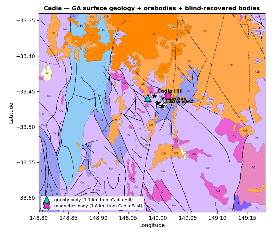 Cadia Valley on Geoscience Australia surface geology, with the Cadia East / Ridgeway / Cadia Hill orebodies located — the geological frame the platform interprets within. Host: Ordovician Forest Reefs Volcanics + Weemalla Formation, intruded by alkalic monzonite; a potassic / calc-potassic core grades out to a propylitic halo.
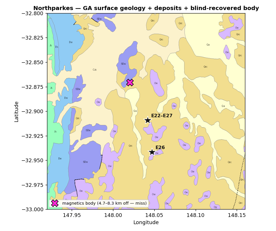 Northparkes / Goonumbla, 200 km northwest. Narrow (<50 m) quartz-monzonite pipes over 900 m of vertical extent in the Goonumbla Volcanics — a geometry that reads very differently in the geophysics, which is the point of testing both.
3 · The conceptual porphyry model
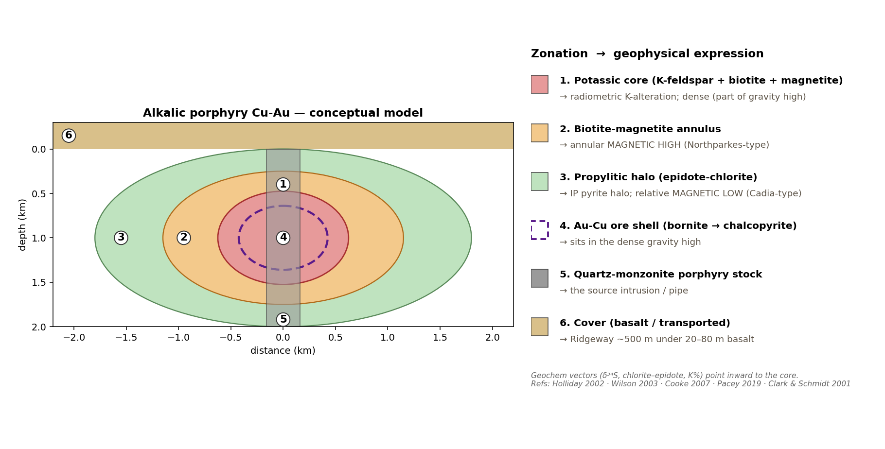 The integrated alkalic-porphyry Cu-Au model the platform interprets against — synthesising geology (monzonite stock with concentric alteration zonation), geochemistry (potassic core → elevated K; chlorite-epidote and sulphur vectors pointing inward; a bornite→chalcopyrite→pyrite metal zonation), and geophysical expression (a gravity high over the dense core and skarn; an annular magnetic high over the biotite-magnetite halo; a relative magnetic low over the magnetite-destroyed ore; an IP response over the pyrite halo). This single model is what ties the separate data layers below into one coherent target picture, and it is built entirely from the published deposit-model literature.
4 · Multi-physics inversion (gravity + magnetics)
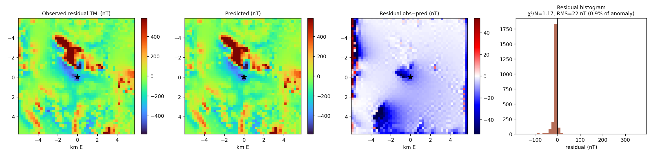 A 3D magnetic inversion reproduces the observed field (residual a fraction of a percent of the anomaly). The gravity inversion independently localises the dense Cadia complex. The platform also ingests surface-wave (Vs), electromagnetic (resistivity), HVSR and downhole data where a survey provides them — the same engine, more physics, better depth resolution.
5 · Surface geochemistry
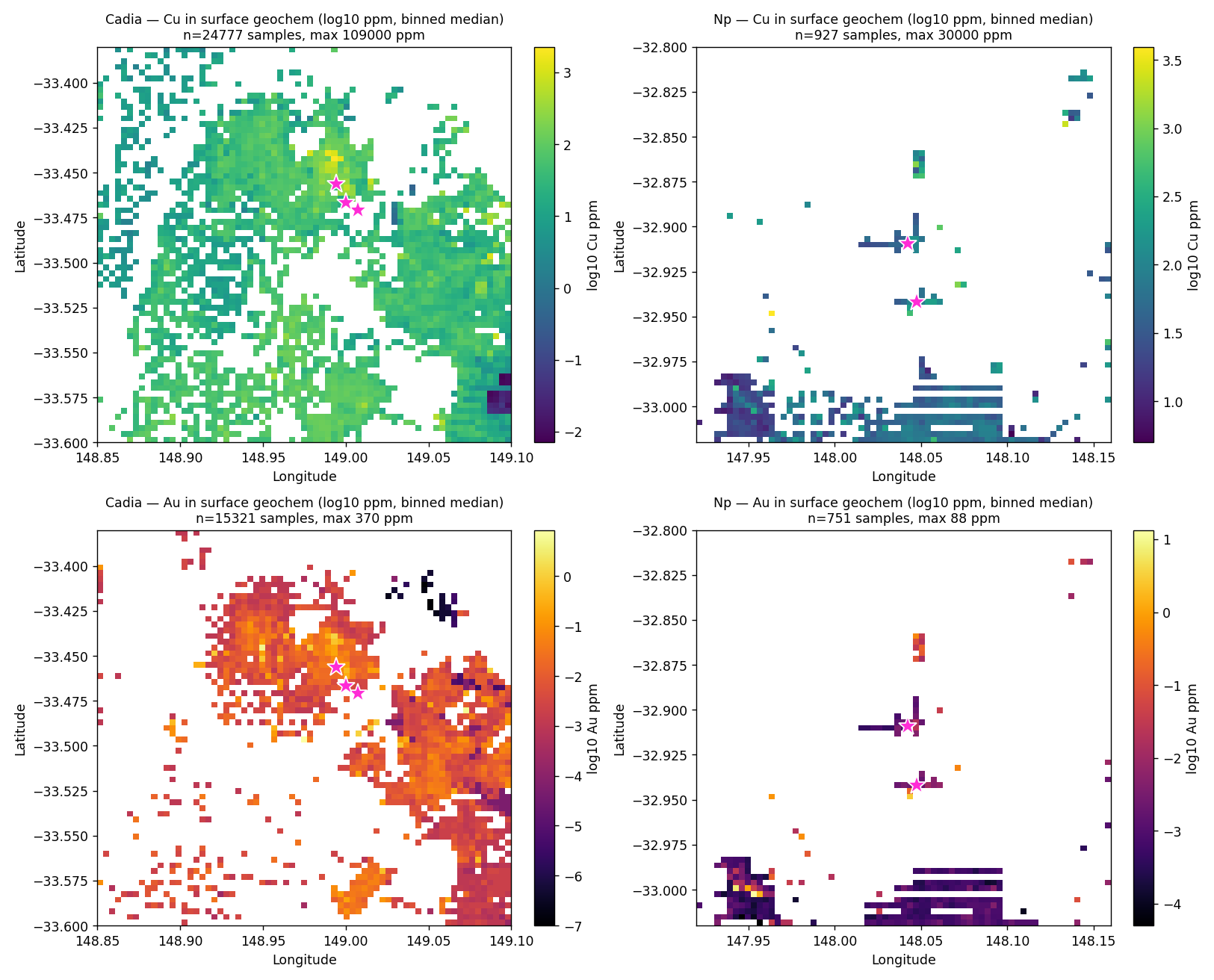 Copper and gold in surface geochemistry (log ppm). The geochemical anomalies sit over the known orebodies — independent confirmation, and a data layer the platform fuses with the geophysics.
6 · Machine-learning prospectivity
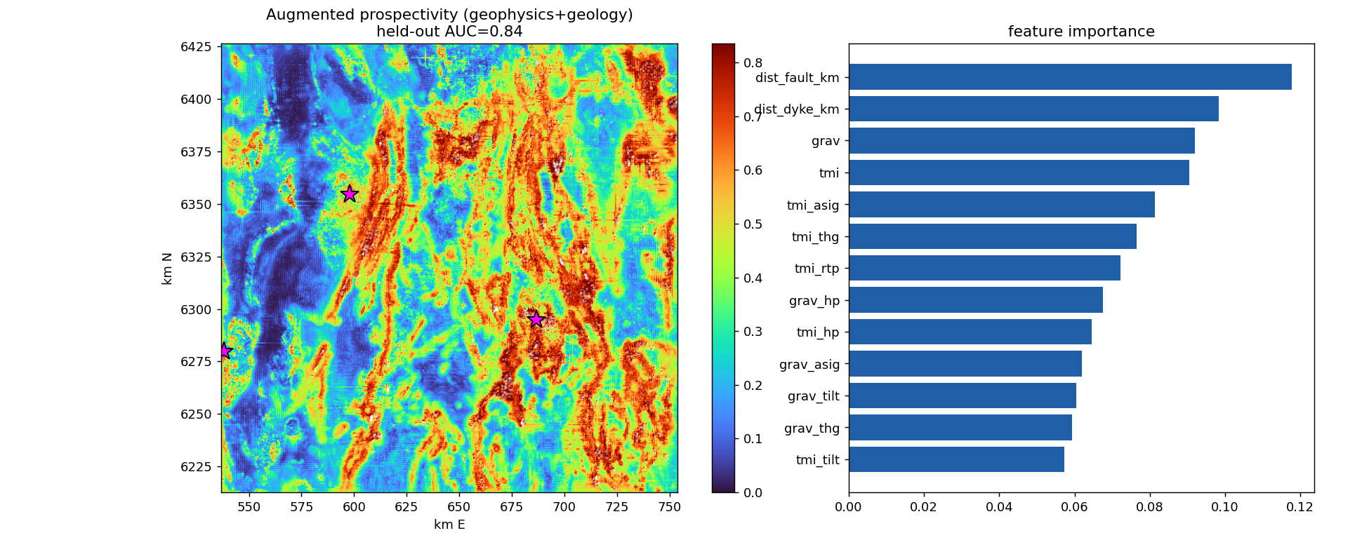 A learned prospectivity model — trained on ~2,000 documented mineral occurrences, with gravity, magnetics and structural (fault / intrusion) features as inputs — ranks the belt for copper-gold potential. Held-out accuracy under spatially-blocked cross-validation (leave-one-quadrant-out) is AUC ≈ 0.65, with the top-scoring 10% of the belt capturing ~14% of held-out occurrences. A random split scores higher (AUC ≈ 0.77) — random splits flatter; the spatially-blocked number is the honest one, and that is the one we publish. (Radiometric and geochemical layers are being folded in as additional inputs.)
7 · How the layers combine
No single method finds every deposit — and the two districts prove it. Each reads through a different physics, set by its own rock properties:
| District | Gravity | Magnetics | What carries the signal |
|---|---|---|---|
| Cadia (Hill / East / Ridgeway) | High — dense skarn, localised to ~1 km | Low — magnetite destroyed in the ore core | a gravity play |
| Northparkes (E26 / E22–E27) | Null — pipes too narrow (<50 m) | Moderate–high — biotite-magnetite annulus + strong structure | a magnetics + structure play |
The opposite fingerprints come from one root cause — magnetite state. Northparkes builds magnetite (a magnetic high); Cadia destroys it (a magnetic low). A single method or threshold cannot catch both, which is exactly why the platform fuses multiple physics rather than betting on one.
And when the layers are stacked, detectability climbs. The table below is each deposit's prospectivity percentile from geophysics alone, then with surface geochemistry added:
| Deposit | Geophysics only | + Geochemistry |
|---|---|---|
| Cadia Hill | 0.84 | 0.99 |
| Northparkes E26 | 0.32 | 0.76 |
| Northparkes E22–E27 | 0.31 | 0.59 |
| Cadia East | 0.38 | 0.28 |
| Ridgeway | 0.35 | 0.28 |
Adding geochemistry lifts the geophysically-expressed deposits sharply (Northparkes E26 jumps from the 32nd to the 76th percentile). The two that drop — Cadia East and Ridgeway — sit under post-mineral cover with muted surface response, the honest signature of deep, covered targets that need drilling or deeper-looking physics. This is the integration the platform is built to do: every layer pulls in the deposits it can see, and the fused picture is stronger than any single one.
8 · What it shows (honestly)
- The platform runs the entire workflow — geology, multi-physics inversion, geochemistry, and machine-learning targeting — end-to-end and fast, on whatever data exists.
- On this ground it recovers the deposits that have a clear signature in the available data and flags the prospective belt with measurable skill; deposits that are deep or magnetically quiet need higher-resolution or additional-physics surveys — which the same platform ingests and inverts jointly.
- This is a capability demonstration on a belt whose deposits are known — which is what makes it honest test ground; every result is reported with its limitations, and figures are reproducible from the public sources.
9 · Why it matters
Tolun is a commodity- and method-agnostic platform: the same engine that produced everything above works on any mineral system and any combination of geophysical, geochemical and drilling data — fusing them with quantified uncertainty and a learning layer that improves with data. Pointed at a client's own dataset, it turns scattered survey and assay data into an integrated, ranked, drill-ready picture.
All inputs are public open-file data (Geoscience Australia, Geological Survey of NSW). This is a capability demonstration; deposit/resource interpretations remain subject to Competent-Person review. © Tolun AI 2026.